Mor Temor
Arch. Mor Temor is international Architecture firm committed to designing unique buildings and one of a kind architectural concepts.

3. City forms: street layouts models
The old cities usually were roughly circular or rectangular in outline (Kevin, 1991). For street layouts, antiquity left two clear and easily understood models: the Hippodamian grid and the Vitruvian radial plan. Their clarity and, evidently, their functionality, prompted their application in a variety of settings (see Fig. 15).
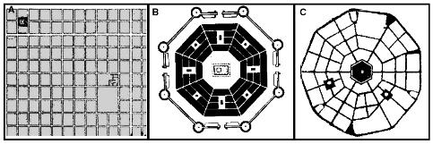
Figure 15 From left to right: (A) a typical Hippodamian grid; (B) the Vitruvian radial plan; and (C) its application in Palmanova, Italy (FANIS, 2008).
The grid was used extensively in the Americas, the uniquely American one-mile grid (Eisner, 1993), and the radial plan appeared in some of Europe’s fortified cities (e.g. Palmanova, Italy; Philippeville, Belgium; Hamina, Finland) and re-emerged sporadically in recent urban and suburban design (e.g. Canberra, Australia; Sun City AZ; Ilioupolis (Athens), Greece) (FANIS, 2008).
The 20th century generated many street layout models (see Fig 16-20). In all cases these plans bear evidence of concern for the pedestrian and, in most, of an attempt to resolve conflicts between foot and motorized travel.

Fig. 16 Typology, from Streets and Patterns (Stephen, 2005).
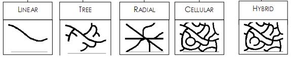
Fig. 17 All Patterns (planar configurations) (Stephen, 2005).
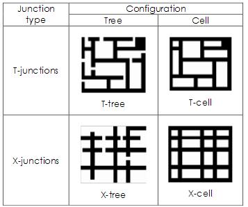
Fig. 18 Network types defined by configurational topology and junction type (Stephen, 2005).
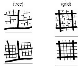
Fig. 19 Simple example of two structures (grid, tree). For each case, the performance and use will be a result of reaction to the whole structure (Stephen, 2005).
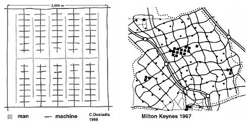
Fig. 20. Doxiadis’s sketch for a ‘man-machine’ separation within a 2km square area framed by
motorways (left) and the Milton Keynes (south east of England)1 km square grid (right). (FANIS, 2008).
The above review of conceptual models for neighborhood, district and city layouts reveals the commonalities and differences in street patterns that seek a balance between wheeled and pedestrian movement. One element on which there is general agreement (at least at the level of professional guidance and practice) is the use of T-junctions for traffic abatement. Another is the use of a hierarchy of streets, beginning with heavily-used inter-city highways, and permitting less traffic on progressively lower level streets. A third element that most models include is partial or complete separation of footpaths from vehicle routes. These paths are generally set in a common green space (Fanis, 2008).
In a brief look, the street patterns should be well differentiated and legible for the person who moves along it. By structuring it around a few unique elements, a sequence of views or events can be created for the motorist or transit rider which will give an underlying rhythm to his experience. A general rule might be to provide a chain of landmarks or events, so that from each point along the street pattern, some identifiable form is in view; once that point comes into view, another then appears. The visual experience can also be made more vivid by the kinetic experience of road motion through bends, dips, and rises. Signing, lighting, and planting can also be varied along the route. General controls on heights, setbacks, bulk, and spacing of structures along the road also help create continuity, legibility and attractive architecture.
The application of the design principles for aiding orientation in space, for instance, helps people to organize their environments in their heads, to understand the behavior expected of them within their cultural frames, and to deal with issues of control of space without ambiguity. Then it will become a true place, remarkable and unmistakable (see Fig. 21).
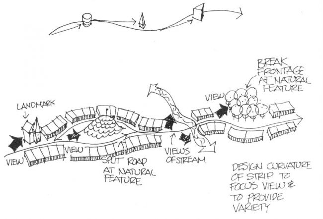
Fig. 21 Conceptual diagram for street patterns.
It is well known that urban form is highly correlated with the evolution of transportation systems (Chunlin, 1998). Modern transportation allows dispersal of the city and also demands more ground area for its facilities (Kelvin, 1991);
In every stage of the development the city gains a temporary form. A city can never have a fixed form, unless it becomes a museum. History shows that a good city is formed on the basis of local characteristics and historical principles rather than by it self or accidentally. More over, the history says that the “good forms and structures” of the city, the ones that strengthen and progress urban activities, and find a balanced relation with local and global environment, are typically protected and have long lives. This is because they have a desirable function and express the history, memories, values, beliefs, and the pride of the city and its citizens. Although formation and construction of a traditional city might be done in a slow and gradual process, without any formal plan or design, but this evolution occurred according to the known and accepted patterns of development.
Today, city is continuously changing along with the quick socioeconomical changes (Anahita, 2009). Modern building technology permits tall, concentrated structures which free the land around them. This pattern provides a new freedom of movement and of use of the ground. Yet towering buildings set on open ground may have only an illusory advantage if overall densities remain high and the open spaces are overloaded. In certain sections, particularly shopping and office areas, there is both a technical and a psychological need for concentration which the open pattern cannot supply. The sense of urbanity and the function of the city as a meeting place for large numbers would be destroyed if an entire city were given over to this new pattern. The modern city requires a rhythmical balance between enclosure and openness, [between] concentration and freedom (Kelvin, 1991).
Arch. Mor Temor